Project: The Living City (Yilong City Masterplan Proposal)
Year: 2017
Location: Yilong, China
Team: Dinithi Iddawela, Cem Kayatekin, Serena Lim, Craig Speck, Luke Janzen


ZONE 1: CITY
The objectives of the city zone are: (1) to support socioeconomic diversity and inclusivity; (2) to frame an urban fabric that is simultaneously dense but also readily navigable by a range of transport modes; (3) to establish water, energy, and waste infrastructure that takes advantage of the potentials of decentralization for the purposes of efficient distribution and long-term systemic stability and viability; and (4) to establish spatial, social, economic, administrative, and cultural ties between the city zone and the other three zones, in order to support the long-term development of the Quishui Lake Area of the broader Yilong District as a non-fragmented whole.
The strategies put in motion in order to achieve these objectives, to be explained in detail in the pages that follow, include: (1) the framing of fine-grained urban-morphological diversity; (2) the activation of the middle sectors of blocks (i.e., the rear portions of building lots); (3) the support of urban density along with the establishment of height limits in order to avoid the pitfalls of unbridled building speculation; (4) the use of performance-based zoning, rather than Euclidean zoning or form-based codes; (5) the design of transport infrastructure around foot, bike and public transport, without neglecting, but by no means glorifying automotive transportation; and (6) the framing of communal nodes at varying scales simultaneously embedded with ecological, institutional, and infrastructural functions.

STARTING POINT: A Standard Urban District
To the left is a section taken from the urban fabric of Manhattan, roughly between 35th Street and 40th Street, that typifies the standard character of the street and block pattern of New York City. This serves as a beginning point of the urban fabric developed for this proposal. One critical advantage that the Manhattan urban fabric has to offer, which is often overlooked, is the wide range of socioeconomic activities that its rather long blocks have historically tended to support, due to the wide range of movements of people and goods that such blocks see, throughout the wide spans they cover.

STEP ONE: Diversify Block and Street Pattern
Two actions are taking place in this step: (1) the rhythm of the broader grid is being kept in place, so that the navigability of the city is not hindered; and (2) the urban fabric is being strategically perforated, allowing for a greater diversity of urban blocks and street patterns to emerge. This diversity in turn begins to open up the city to a wider range of urban conditions which in turn have the capacity to support the needs of a wider range of socioeconomic activities.

STEP TWO: Activate Middle of Blocks
In most cities, the centers of blocks are occupied by building setbacks that allow for certain lighting and ventilation requirements to be maintained. In this proposal, we have opened up these back-of-house spaces to the public domain, allowing for a secondary street front to be established. Reinforcing the efforts of the previous step, this allows for an even further range of urban conditions to begin to exist in the city, which in turn has the potential to support the activities of a more-diversified socioeconomic fabric.

STEP THREE: Establish Fine-Grained Plotting
A financial and legal framework that reinforces the potential for a diversified socioeconomic fabric, is critical. An important part of this process is the framing of lot sizes. Within this proposal, we have established parcel widths that average around 9m. This scale of plotting allows for smaller-scale economies to find smaller-scale niches within the urban fabric, while simultaneously not hindering the capacity of larger-scale entities from combining lots when needed. The following page describes the steps taken to ensure that such agglomeration, when it does occur, doesn’t spur a homogeneity of large-scale construction and speculation from taking over the urban fabric as a whole.

Diagram depicting the middle-of-block alleyways, and the water-infrastructure components they support (left) and the 10.5m roads within the city proper and the modes of transport they support (right).
As is framed in the sections prior, the main objectives outlined for the city zone are: (1) to support socioeconomic diversity and inclusivity; (2) to frame an urban fabric that is simultaneously dense but also readily navigable by a range of transport modes; (3) to establish water, energy, and waste infrastructure that takes advantage of the potentials of decentralization for the purposes of efficient distribution and long-term systemic stability and viability; and (4) to establish spatial, social, economic, administrative, and cultural ties between the city zone and the other three zones, in order to support the long-term development of the Quishui Lake Area of the broader Yilong District as a non-fragmented whole. The strategies put in motion in order to achieve these objectives, include:
(1) The framing of fine-grained urban-morphological diversity. The establishment of fine-grained lots, in conjunction with buffers of communal lots and public space, help to support the maintenance of socioeconomic footholds for small-to-mid-scale development, while simultaneously buffering against the potential pitfalls of XL-scale urban speculation and lot agglomeration.
(2) The activation of the middle sectors of blocks (i.e., the rear portions of building lots). Effectively, this proposal doubles the urban street frontage by activating the middle portions of blocks to pedestrian and bicycle traffic. Opening up these alleyways also gave the opportunity to activate this space with components of the broader decentralized water infrastructure that plays a critical role in the broader system’s functions of water conservation, retention, and aquifer regeneration.
(3) The support of urban density along with the establishment of height limits in order to avoid the pitfalls of unbridled building speculation. The city proper for this proposal occupies 0.594km2. After the exclusion of infrastructure, public space, and institutional space, with height limits set at 8 stories for facades facing the street, and 5 stories for facades facing the alleyways, the city proper, at its maximum density, is able to support a population of 43,156 people (or 72,653 people / km2), that is assuming an allotment of 23m2 dwelling space, and 23m2 socioeconomic space per person within the urban fabric (which incidentally appears to be higher than the 19m2 per person frequently noted within the literature concerning the subject as the average in major cities in China).
(4) The use of performance-based zoning, rather than Euclidean zoning or form-based codes. As described in other locations of this proposal, the use of performance-based codes, as opposed to Euclidean zoning or form-based codes, allows for a much higher potential, and much more rapid pace, of bottom-up development, while simultaneously protecting the broader context from unexpected externalities by hindering high impact development and supporting low-impact development.

(5) The design of transport infrastructure around foot, bike and public transport, without neglecting, but by no means glorifying automotive transportation. The design of the road systems for this proposal attempted to limit, as much as possible, the area within the urban fabric taken up by automotive infrastructure, without neglecting the reality that automotive mobility invariably activates the urban fabric in a critical manner, specifically in the transport of goods and people. Within the city proper, roads were set at a width of 10.5m, allowing for two bike lanes, two car lanes, and a parking/loading lane.

(6) The framing of communal nodes at varying scales simultaneously embedded with ecological, institutional, and infrastructural functions. A critical leap in this proposal was to create adjacencies between combined heating / cooling / power generators, water treatment infrastructure, and transit infrastructure. In the context of heating, cooling, power, and water infrastructure, larger scale nodes are placed at strategic transition points between the four zones, that would be connected to a decentralized network of smaller heating / cooling / power transfer nodes, working as secondary points within the urban fabric, transitioning more centralized inputs to the level that is required for the building scale.
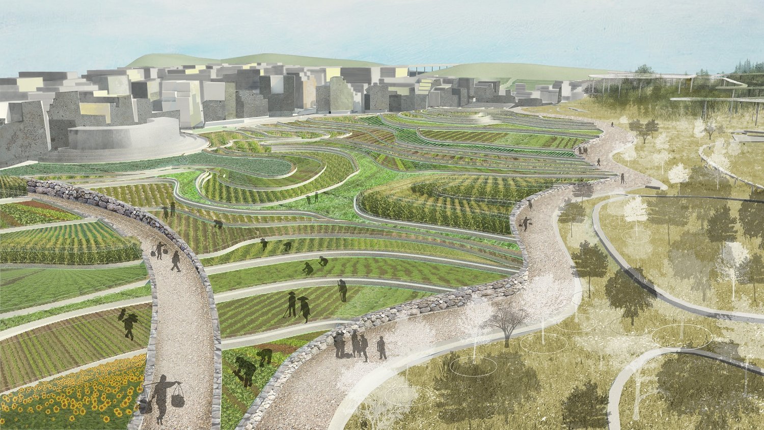
ZONE 2: AGRICULTURE
The objectives of the agricultural zone are anchored around: (1) supporting the short- and long-term stability and viability of food production systems in close proximity to the city proper; (2) functionally and visibly re-establishing the close relationship between the consumption tendencies of the city, and the food production capacities of the proverbial hinterland; (3) supporting innovation and experimentation within the realm of low-impact, polycultural agriculture; and (4) creating constructive adjacencies between agriculture and the other three zones that would support innovative relationships particularly in the realms of agricultural and permacultural performance, and water / waste / energy infrastructure. The efforts set in motion to support these objectives, outlined prior, are described in greater detail here:
(1) The application of output and emission-based regulation (e.g., performance- based zoning, in a sense) on agricultural production. The goal of performance- based zoning, as described in the city zone, is ultimately to establish a framework of systemically manageable inputs and outputs, and allow for societal developments, changes, revisions, to occur in a bottom-up manner inside that framework. The development that occurs in this context, of course, is of a food-production variety, which, due to the protections established via this performance-based framework, is pushed towards innovation and experimentation within the realm of low-impact socioeconomic behaviors.
(2) The framing of agricultural land in close proximity to the city proper, in conjunction with the establishment of actual administrative ties between these two zones, in order to support social, economic, and cultural relationships and exchange. The primary mechanism for this connection, as mentioned elsewhere, is the establishment of collectives. That is, urban, agricultural, and stewardship collectives that join together as triplets to form socioeconomically diverse administrative bodies, or collective councils. Each council, of which there would be many within the Quishui Lake Area, would be composed of an urban collective, an agricultural collective, and a stewardship collective. Significant decisions concerning the different zones, in turn, would be made through these councils. This would not only allow for broad decisions to be made within a robust and well-rounded framework, but also establish the seedlings for interzone discussions, collaborations, and experimentations to take place.
(3) The close juxtaposition of agricultural land with the broader ecological system, in order for agricultural producers to be able to learn from, take advantage of, and potentially adopt, the benefits that localized polycultures and permacultures have to offer. Polycultural or permacultural ecological systems, whether naturally occurring or man-made, have critical lessons and systemic resources they can share with more-traditionally tended agricultural land (and vice versa). This project merely supports this potentially profoundly informative relationship, spatially and programmatically, in order for the various domains of food production to be able to pursue the inherent innovative and constructive aspects that such a relationship innately has to offer.
(4) The establishment of small and medium- scale agricultural platting, separated by strategic public-domain buffers, in order to support the activities of small-scale farmers, while simultaneously buffering the unchecked growth of extra-large scale monocultural producers. Rather similar to what is framed within the city proper, the method of small-to- medium scale platting, in conjunction with the act of buffering against extra-large scale land conglomeration through the establishment of public roads and plazas, allows for the short and long-term support of smaller-scale agricultural production.
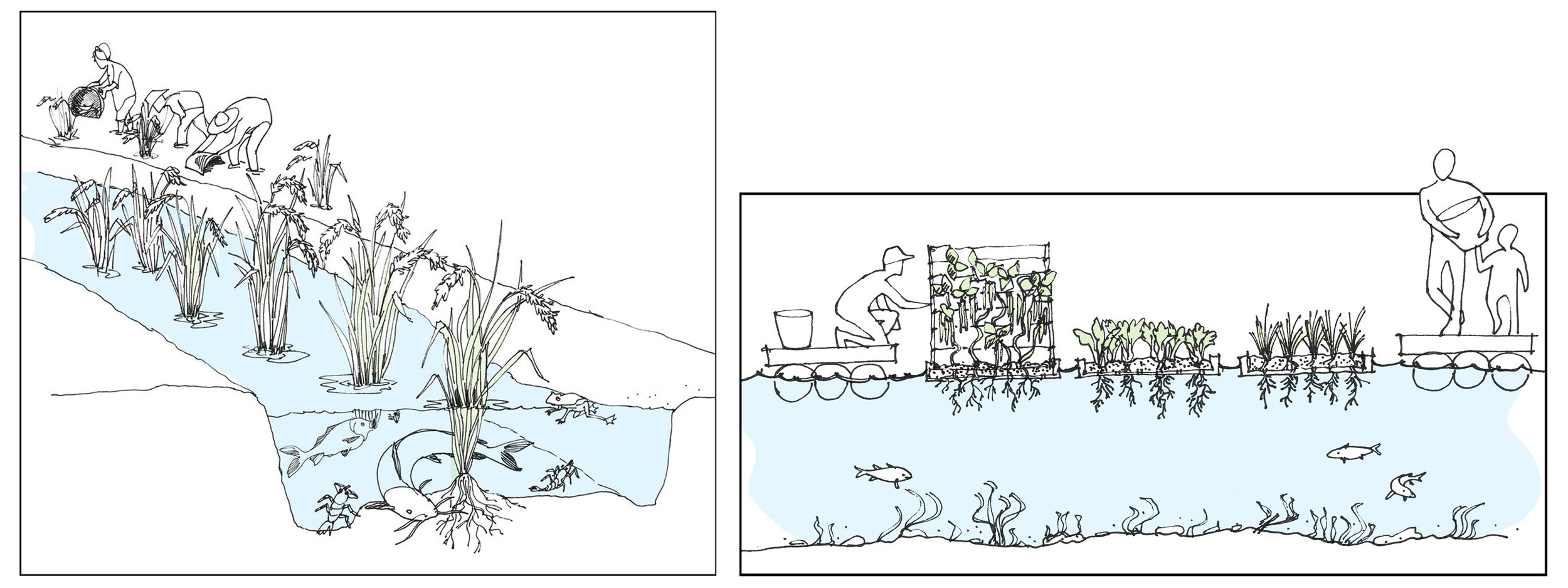
Diagram depicting a potential polycultural setting, specifically focused on the constructive and reciprocal relationships found between a range of species in the context of traditional rice paddy fields (left). Diagram depicting a potential aquaponic agricultural setting. This kind of development, which offers quite interesting potentials in terms of polycultural production systems, could be experimented with within urban communal gardens, within the stewardship zone, as well as the agricultural zone (right).

ZONE 3: STEWARDSHIP
The objectives of the stewardship zone are: (1) to establish a domain supportive of low-impact permacultural farmsteading, as appears to have been historically practiced within this region; (2) to buttress the broader ecological system’s functions revolving around biodiversity, water retention and conservation, and aquifer regeneration; (3) to create a close linkage with the other three zones, in order to support short- and long-term networks of socioeconomic and cultural exchange. To support these objectives, the following approaches, discussed earlier and detailed below, were embedded within this zone:
(1) The application of performance-based zoning criteria that would support the propagation of settlement patterns akin to those observed within regional low-impact permcultural farmsteads, e.g., the local Bouyei and Miao farmstead communities. Similar to what is discussed within the other zones, the application of performance-based zoning opens up the area to widespread, bottom-up development, but regulates the potential impact that such development can have on the existing fabric.

(2) The strategic development of terraced agricultural areas, as are typically used for, but not limited to the needs of, rice paddy fields, that appear to form a staple crop of local populations engaged in permacultural practice. The stewardship zone is largely modeled off of the historic and contemporary settlement and food-production patterns of regional communities that have traditionally engaged in permaculture. The establishment of agricultural lands supportive of paddy fields in this manner, is another such example of this.
(3) The formation of public space and roads that would serve to connect the stewardship zone to the city proper [...]. This, in conjunction with similar such actions throughout the other zones, opens up the broader Quishui Lake Area to a diversity of potential live-work situations and supports the potentials of widespread socioeconomic mobility.

ZONE 4: LAKE
As explained in the introductory section, the objectives of the lake zone are anchored around: (1) supporting the broader ecological system’s functions of water conservation, retention, and aquifer regeneration, along with the maintenance and reinforcement of biodiversity; (2) supporting and reinforcing the ecosystemic niches critical for the life stages of various species; (3) framing spaces supportive of a range of social and cultural activities, in order to engage the public with the critical ecological systems underpinning the urban condition; and (4) promoting socioeconomic exchange and innovation, particularly in the realm of agricultural and permacultural innovation.
To set these objectives in motion, the following schemes were established, and are detailed further below:
(1) The establishment of the lake zone as an active ecological protected area. This strategy in many ways functions rather similarly to the proverbial urban growth boundary, however the critical distinction is that while an urban growth boundary is often established around an idealized size or geography for a city, this active ecological protected area is established around the geographic and biological space required for the maintenance of a robust and diverse ecological system. Therefore while the urban growth boundary can often be altered according to shifting conceptions of idealized urban size or geographic limits, this active ecological protected area is embedded with a much more resolute protection against potential short- and long-term encroachments due to changing socioeconomic, political, or intellectual pressures.
(2) The promotion of institutional research focused on efforts at reinforcing the diversity of species and ecosystemic niches within the area. The rejuvenation of wetlands, the use of floating farms both as nodes of research and public engagement, and the broader maintenance and reinforcement of the movements and dynamics of the ecological system herein, are all framed within this proposal as opportunities for research, experimentation, innovation geared towards the support of the spatial and biological diversity inherent to the ecological systems of this area.
(3) The establishment of public paths, nodes, and gathering spaces, that support public engagement with this active ecological preserve. This project proposes that critical sustainability requires the inclusivity of humans within ecological systems, whether it be via mechanisms of public engagement, research, or active stewardship. The floating farms, viewing nodes, community spaces, canopy walks, raised roads and pathways, all play a critical role in this process.


The overall objective for this proposal was first, to unveil the innate human and non-human ecological systems that play critical, and often overlooked, roles within the complex dynamics of the urban condition, or more broadly, the condition of human settlement; and second, to mobilize these roles in shaping an urban model that could serve as a prototype for future city-scale proposals. This project serves, in essence, as a critical analysis into the multiplicities of systems that occupy the root, the fundament, of the urban fabric, and simply supports their physical manifestation at the proper physicality, at the proper visibility, that they must have, if the modern city is to leave a resolute and meaningful legacy within, and beyond, the twenty-first century.
THE LIVING CITY
This proposal for the Quishui Lake Area of the Yilong District is anchored around the development of four zones that play critical roles within the human and non-human ecological systems underpinning the multiplicity of functions inherent to the urban condition. They include: (1) the city zone; (2) the agricultural zone; (3) the stewardship zone; and (4) the lake zone. The overall objective in framing the city in this manner, is to conceive of the urban condition in its full scope, including the physical fabric of the city of course, but expanding also to embrace and support the living and non-living infrastructural systems, the issues of biological and socioeconomic diversity and inclusivity, the long-term viability of localized food systems, and beyond, that are deeply intertwined within the complex network of reciprocal relationships innate to the city.